ICESat-2, NASA’s new satellite to measure the melting of ice

On Saturday the 15th of September, NASA launched their newest laser, the ICESat-2, which stands for “Ice, Cloud and land Elevation Satellite”. In orbit 500 km above our heads, the satellite’s main mission is to measure the alarming evolution of ice melting in the poles.
Since 2009 and the end of the first mission of ICESat, NASA had no spacecraft instrument capable of providing information such as the thickness of the ice in Greenland and the Antarctic. On board of the half a tonne satellite, two lasers, one of replacement, were installed. Each laser is divided into six beams to follow as closely as possible the slope of the surface of Earth. With 10,000 laser pulses per second, measurements will be taken every 70 centimetres on the trajectory of the satellite. Thanks to these very precise data, NASA aims “to estimate the annual height change of Greenland and Antarctic ice sheets to within 4 millimetres – the width of a No. 2 pencil.” ICESat-2 records the time taken by the laser beams to reach the Earth and to come back to the satellite at a very precise spatial location. Scientists are then able to calculate the height of forests, glaciers and sea ice.

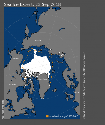
Such devices are urgently required in today’s global warming situation. The Arctic Sea Ice has indeed reached its smallest 2018 summertime surface area (4.59 million square kilometres) on September 23rd. This layer of frozen water floating above the Arctic Ocean extends during wintertime and naturally shrinks during summer. However, since the 1970s, the Arctic Sea Ice rapidly reduced by 54 000 square kilometres each year, going from 7.01 million square kilometres in 1980 to only 2.91 square kilometres in 2012! The same phenomena are observed in the Antarctic, where 3 000 billion tonnes of ice have melted since 1992, enough to rise the global level of the oceans by 8 millimetres! Hundreds of millions of inhabitants living on coastal land are under the threat of sea level rising! The future measurements provided by ICESat-2 will supply more details to the world’s leaders to orientate their policies in favour of sustainable development and take action to prevent the Earth’s temperature from rising by more than 1.5°C by 2022.


